Marangu Route
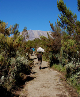
Probably the more popular route on Kilimanjaro, this route offers hut accommodation at all 3 camps. The route starts at the Marangu Parks Gate (1 800 m) where a well defined path heads into the rainforest until it reaches camp 1 - Mandara Hut (2 727 m) on the rainforest belt. Maundi Crater (2 800 m) is about a 15 minute walk from camp and is worth a visit.
On the second day there are gorgeous views of Mawenzi (5 149 m) and the south-eastern slopes of Kilimanjaro. These views dominated the sky line all the way to camp 2 Horombo Hut (3 720 m). Expect temperatures to drop below freezing with a possibility of frost in the mornings. An extra day for acclimitisation is highly recommended and allows for a hike to Mawenzi Hut (4 600 m). On route to Mawenzi you will pass Zebra Rock, one of natures miracles youll see along the route. As you proceed along in a northerly direction, youll reach a junction where there is a memorial plaque to Loretta Mae Hendricks who lost her life on the mountain in April 1979.
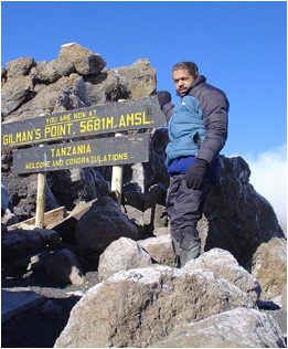
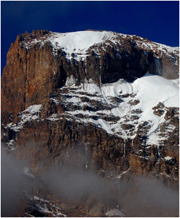
From this point you can view The Saddle and the south-eastern slopes of Kilimanjaro. The steep scree path ascending to Gillmans Point (5 685 m) is also clearly visible. This extra day is highly recommended and can increase your chances of reaching the summit. Camp 3 - Kibo Hut (4 703 m) is reached after a hike through the semi-desert landscape of The Saddle. On summit night you will follow a winding rocky footpath to Hans Meyer Cave (5 150 m).
After passing the cave you continue up the steepest section that zigzags to Gillmans Point (5 685 m). From Gillmans Point (5 685 m) you continue along the crater rim to Stella Point and eventually Uhuru Peak (5 895 m) the highest point on the African continent.
Machame Route
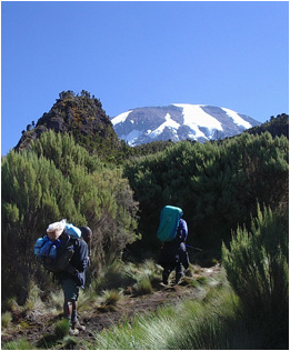
Without a doubt, this is the most scenic route on Kilimanjaro. The path starts at the Machame Gate (1 800 m) and heads into the pristine forest eventually reaching camp 1 - Machame Hut (3 000 m). From camp there are views of Meru Peak and the Western Breach of Kilimanjaro. The path from Machame Hut to Shira Hut (3 840 m) heads into the moorland and offers great views of the Shira Needle, Shira Cathedral and East Shira Hill.
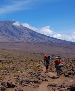
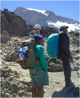
On day 3 you will reach an altitude of about 4 600 m at Lava Tower. The walk from Lava Tower to Barranco Hut (3 950 m) offers great photo opportunities of the awe-inspiring Western Breach and Breach Wall. Barranco Hut is located in a valley below the Breach and Great Barranco Walls. After ascending the almost vertical Barranco Wall to an altitude of about 4 200 m, the footpath crosses through the south-western slopes to reach the Karranga Valley. From here you ascend a ridge along a footpath that leads to Barafu Hut (4 600 m). On a clear day The Saddle and Mawenzi (5 149 m) can be seen to the east.
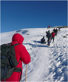
At around midnight you'll head up the South East Valley towards Stella Point on the crater rim and eventually reach Uhuru Peak (5 895 m). This stretch offers great views of Rebmann, Decken, Kersten and Heim Glaciers. From Uhuru Peak you can also see Furtwangler Glacier and the Eastern Ice Fields. Above all, you will also be rewarded with just about the most beautiful African sunrise ever. If you choose to summit via Arrow Glacier, from Lava Tower you will ascend to Arrow Camp (4 800 m). Just before midnight you head up the Western Breach eventually reaching the crater rim - Kibo. The path continues past Furtwangler Glacier and the Crater campsite, to reach Uhuru Peak (5 895 m) you need to ascend a gradual slope that leads to the highest point on Kibo.
Umbwe Route
Undoubtably the less utilised and shortest route to the Western Breach. This route makes the distances covered between camps shorter and avoids crowding experienced in some sites in season.
An ascent to Kibo via the Umbwe Route is quite taxing, primarily due to the relatively fast ascent to higher altitudes, but the rewards are plentiful. Fewer people, pristine forest, greater chances of seeing wildlife and bird life in the lower levels, and shorter walking distances make it a great option for fit hikers.
There are two main ascents on the Umbwe Route, via Barafu Hut or Arrow Glacier. Although both of these options can be done in 5 days, a 6-day hike is recommended for correct acclimatisation.
From the Umbwe Gate (1 700 m) you will walk through the spectacular forest to camp 1 - Bivouac 1 (2 900 m). The path generally keeps to a narrow ridge crest between the Lonzo River on the west and the Umbwe on the east. Altitude is gained quickly with some spectacular views of deep gorges, and if you are lucky glimpses of Kilimanjaro towering above you in the distance.
Camp 2 on this route is Bivouac No 2 (3 780 m), if youre feeling strong, then you may continue to Barranco Hut (3 950 m). The path is fairly steep through the forest, heading along a sharp ridge before it flattens as you approach Barranco Hut in the moorland zone. A fairly long and strenuous day, you will now start to feel the symptoms of altitude.
Rongai Route
This is undoubtedly one of the least utilised routes on Kilimanjaro; you will camp expedition style in high altitude tents. The route starts at the Rongai Parks Gate (2 000 m) and follows a well defined path leading through a plantation and maize fields eventually reaching the rain forest. There is a wide variety of trees to see when trekking through this narrow band of forest before reaching camp 1 Simba Camp (2 850 m), this camp is situated on the upper borders of the rain forest belt. There is a possibility of encountering wildlife in the form of Lion, Buffalo and Elephant; an armed ranger will escort hikers on their second day to Second Cave (3 450m). Day 2 presents gorgeous views of Mawenzi (5 149 m) and the north-eastern slopes of Kilimanjaro.
Mawenzi and Kibo will dominated the sky line until you reach camp 2 - Kikelewa Camp (3 600 m). Expect temperatures to drop below freezing with a possibility of frost in the mornings. An extra day for acclimatisation is highly recommended, on this day you will hike to the picturesque Tarn Hut (4 330m), this camp has a fresh spring water lake and is located on the lower slopes of Mawenzi swimming in the lake is strictly prohibited. As you proceed along in a westerly direction, youll reach a high point above a ridge that offers stunning views of The Saddle and the south-eastern slopes of Kilimanjaro. The steep scree path ascending to Gillmans Point (5 685 m) is also clearly visible. This extra day is highly recommended and can increase your chances of reaching the summit.